NEWS: Alert over Mount Agung, BALI June 29, 2018 (12:00 GMT)
Bali Luxury Villas is observing the news and updates about the seismic activity of Mount Agung in Bali. Only official and firsthand information sources are being reported here, as a help to avoid being mislead by the numerous internet hoaxes and clickbait news.
BALI June 29 2018 (12:00 GMT): Update
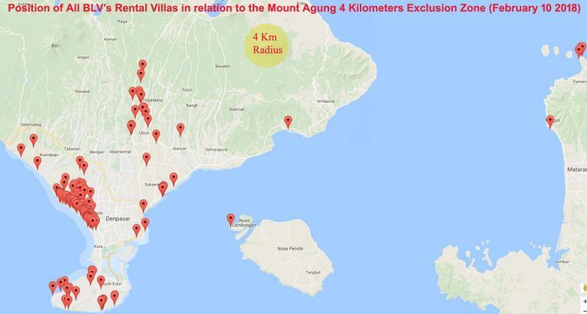
The head of the Geological Agency, (ESDM), Rudy Suhendar said at the press conference that the seismic activity of Mount Agung remains low, and there is no need for the community to evacuate. The 4 Km safety radius established in February remains the same, see below. Following today's eruption Denpasar airport was briefly closed, and reopened at 2:30 PM local time (see NOTAM Notice A2551/18). Lombok international airport is also operating normally. BNPB's Sutopo Purwo Nugrobo stated that the ash distribution is not widespread and shared a satellite photo.
BALI February 13 2018 (10:00 GMT): Update
BNPB's Sutopo Purwo Nugrobo announced that as of February 10 2018, the exclusion zone around Mount Agung's crater is further reduced from 6 km to 4 km. The Frequency of Mount Agung eruptions has decreased. All Villagers previously displaced are now allowed to return to their homes. Full statement in Indonesian by the Ministry of Energy & Mineral Resources No 0015.Pers/04 /SJI/2018 can be read here. Today's eruption (which occurred on Feb 13 at 11:49 Local Time) does not change the decision to lower the exclusion zone to 4 km.

BALI January 4 2018 (10:00 GMT): Update
BNPB's Sutopo Purwo Nugrobo announced that the exclusion zone around Mount Agung's crater is now reduced from 10 km to 6 km. Villagers who live between the 6 and 10 km radius are now allowed to return to their homes. Full statement in Indonesian by the Ministry of Energy & Mineral Resources No 002.Pers/04/SJI/2018 can be read here.
BALI January 2 2018 (19:00 GMT): Update
BNPB's Sutopo Purwo Nugroho announced that a new eruption took place at Mount Agung on January 1st 2018 around 22:03 local time. The ash cloud remains very local and the area outside of the 10 km exclusion zone (See below) is safe and normal. Air traffic remains normal.
BALI December 12 2017 (23:00 GMT): Update
Bali's Ngurah Rai International Airport and Lombok Praya International Airport, have been operating normaly since November 30 2017. No new NOTAM (Notice To Airmen) related to airport closures since then.
BALI November 29 2017 (08:00 GMT): Update
Bali's Ngurah Rai International Airport reopened today 29/11/2017 14:58 Local time and is operating normally. Notam Notice A4300/17.
 BALI November 29 2017 (00:00 GMT): Update
"The closure of Bali's Ngurah Rai International Airport is extended until 30/11/2017 07:00 Local time. Not all countries have volcanoes. Indonesia has 127 active volcanoes. The eruption can be enjoyed by tourists in a safe place. Foreign tourists are fascinated by the eruption of G. Agung." said BNPB Sutopo Purwo Nugroho. The NOTAM notice may change, Given the direction of the wind, the airport is likely to re-open by the end of today, Stay tuned. Tourists who wish to witness Mount Agung eruption, must stay outside of the exclusion zone of 12 Km from Mount Agung crater (See Maps below) to enjoy a safe view. Below practical information (Nov 27) remains valid, for guests who need to leave urgently and use alternative airports, or contact their airlines.
BALI November 28 2017 (00:20 GMT): Update
The closure of Bali's Ngurah Rai International Airport is extended until 29/11/2017 07:00 Local time, while Lombok International Airport reopened this morning, 28/11/2017 at 06:00 Local time, and operates normally: Notice To Airmen NOTAM 8916/17 (Lombok Airport: +62 370 6157000 ext 888). Evaluation continues, twitted by BNPB Sutopo Purwo Nugroho. Below information (Nov 27) remains valid.
BALI November 27 2017 (02:00 GMT): Update
The Bali Tourism Hospitality Task Force informed that Bali’s Ngurah Rai International Airport is closed from 7:15 am local Bali time on November 27 until Tuesday November 28 7:00 am. While the sun is shining and there is little sign of volcanic ash in the southern regions of Bali, presence of volcanic ash at higher altitudes on aviation approach and departure paths has prompted the decision to close the airport. Visitors with an urgent need to continue their journey might consider an overland journey by bus and ferry directly from Bali airport to Surabaya Juanda airport (approximately 12 hours, and a fee of 25 US$ inc. meal). If you need further information regarding your flights schedule or travel option, please call Mt Agung Command Post on the 2nd floor of Ngurah Rai International Airport: (0361) 9351011 ext: 6300. (Some travellers have been transferred from Bali Ngurah Rai Airport to Mengwi Bus Terminal and Padang Bay Sea Port to go to their departure site from Blimbing Sari Airport (Banyuwangi), Juanda (Surabaya) or Lombok Praya (West Nusa Tenggara)).
To prevent visa overstay or if you wish to exit the country using alternative airports, the Indonesian immigration service is also standing by at the Airline Command Post on the 2nd Floor.
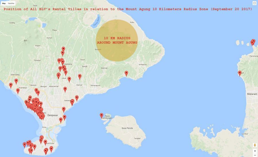
The “danger zone” is a small area with a radius of approximately 10 km from Mount Agung’s crater (see images below). Tourist visitors in Bali are reminded there is no reason to panic and are advised to stay in their hotels where the hotel management and the relevant government agencies will keep them fully informed on developments. While the airport is closed, guests who are not in an urgent need to depart can extend their stay at discounted rates.
Links to real time Bali airport (Ngurah Rai) DEPARTURE and ARRIVAL flight status webpages.
Links to real time Surabaya airport (Juanda) DEPARTURE and ARRIVAL flight status webpages.
International Airlines Contact Centers:
- Air Asia: +62 361 760116, 755799
- Air France: +62 361 755523
- Air New Zealand: +62 361 756170
- Batik Air: +62 21 633 8345
- British Airways: +62 361 288511
- Cathay Pacific Airways: +62 361 286001
- China Airlines: +62 361 287840 ext 1107
- China Eastern: +852-3665 8388
- China Southern: +86 4006695539 & +62 21 579 58222
- Citilink: +62 31 2931100
- Emirates: +62 21 29345555
- Etihad Airways: +62 21 5202268
- Eva Air: +62 361 756488
- Garuda: +62 21 23519999
- HongKong Airlines: +852 3916 3666
- Jetstar: +62 803 852 9779 & +61 39645 5999
- KLM Royal Dutch Airlines: +62 21 29272222
- Korean Air: +62 361 288511, 289402
- Lion Air: +62 21 6379 8000
- Lufthansa: +62 361 287069 ext 1312, 1311
- Malaysian Airlines: +62 361 288511, 288716
- Malindo Air: +60 37841 5388
- Qantas Airlines: +62 361 288331, 288333, 289280, 751472
- Qatar Airways: +62 361 9360274 & +974 4420 3015
- Royal Brunei Airlines: +62 36 757 355 & +673 2212222
- Scoot: +62 21 8063 0063
- Singapore Airlines: +62 21 550 7130 Ext. 32
- Sriwijaya Air: +62 21 292 79777
- Thai Airways Int Ltd: +62 361 288141, 288063
- Tigerair: +61 7 3295 2104
- Transnusa: +62 361 787 7555
- Virgin Australia: +61 7 3119 7042
- Wings Air: +62 21 6379 8000
- Xiamen Air: +62 21 57948316 & +86 592 2226666
National Disaster Management Agency (BNPB) Sutopo Purwo Nugroho explained on Wednesday (11/22/2017), that the cloud above the crater of Mount Agung is caused by Phreatic steam. "Tourism in Bali remains safe, Ngurah Rai International Airport is safe and normal. Other areas in Bali (Outside of the 7.5 Km radius from Mt. Agung) are also safe. Do not be afraid." - said BNPB Sutopo.
Following a decrease in seismic activity, status of Mt. Agung was reduced from level 4 to 3 on October 29 2017, and the exclusion radius was reduced from 12 Km to 7.5 Km from the crater. Most villagers were allowed to return to their homes, however everyone must remain outside of the 7.5 Km safety radius. As of November 22, the status remains at level 3 as there is no increase of seismic activity. Winds are currently blowing mildly toward the east-southeast away from the airport. All our rental villas are located much further away than the current exclusion radius of 7.5 km from Mount Agung (See Maps Below).
Official statement: Mt. Agung Showed Phreatic Activities: Communities to Remain Calm, Not to Panic.
BALI October 11 2017 (20:00 GMT): Update
"If the Mt Agung Eruption Occurs, Bali Still a Safe Travel Destination" the Bali Tourism Board has assured. "According to the information of BNPB (National Disaster Management Authority), 98 percent of the tourist areas in Bali are safe in case of Mount Agung eruption." said Dewa Gede Ngurah Byomantara. The area outside the 12 kilometers of the Mount Agung crater is in the safe category - Ministry of Foreign Affairs, Republic of Indonesia.
Full official statement: http://kemlu.go.id/en/berita/Pages/Should-the-Mt-Agung-Eruption-Occurs,-Bali-is-Still-Safe-for-Tourism.aspx
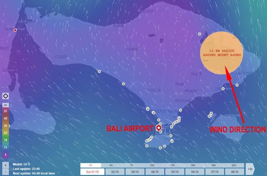
As of October 11, winds continue to blow from the south toward the north (potencially pushing clouds from Mount Agung away from the airport) and are forecasted to continue to do so for the foreseeable future. According to the Ministry of Transport, use of alternative airports in East Java and Lombok and passenger transport to those airports have been anticipated to ensure tourist accessibility. However, as a consequence of favorable wind direction, should the volcano erupt, there is a chance that the airport will remain open.
Real time updates on wind direction: https://www.windfinder.com/#10/-8.4731/115.5521
On October 4 2017, Bali Governor Made Mangku Pastika met with representatives from 35 foreign consulates and told the foreign consuls that visitors to Bali do not need to worry about the conditions on Mount Agung. He said that in the event of an eruption of Mount Agung, only 28 villages in the Regency of Karangasem living in the foothills surrounding the mountain are considered in danger. All the residents of these communities have been evacuated: http://kemlu.go.id/en/berita/berita-perwakilan/Pages/Governor-Calls-on-Consulates-to-Assure-Bali-Remains-Safe-for-Tourist-Visitors.aspx
BALI October 1st 2017 (05:30 GMT): Update
"There are no visual signs yet that Mount Agung will erupt soon. So don't be afraid to come to Bali, it's still safe. And if the mountain erupts, it's still safe as long as people stay out of the (12 Km) dangerous zone," said national disaster mitigation agency spokesman Sutopo Purwo Nugroho.
Indonesian Transport Ministry spokesman Bambang Ervan said the government has contingency plans to deal with the possible intermittent closure of the Bali airport, should the Mount Agung erupt and continue to do so for a prolonged period. "Closing an airport has to do with the direction of the volcanic ash. At the moment the wind is blowing northeast so if the volcano erupts, there is a chance that Ngurah Rai airport could remain open,” he said. If the airport closes tourists could be ferried across to the airports on the neighbouring island of Lombok, or to Ketapang, in East Java. Tourists in Bali will be supported by the Bali Tourism Hospitality Task Force (+62-812-46119889 +62-877-54689166) in case of eruption of Mount Agung.
During this period of the year, winds generally blow from the south toward the north, away from the airport. Real time wind direction and forecasts for the weeks to come can be seen at: https://www.windfinder.com/#10/-8.4731/115.5521
Wind direction in relation to Mount Agung, and the Airport on October 1st 2017 can be seen below:

Bali Governor I Made Mangku Pastika emphasized it is safe for those who live outside the 12km zone to return to their homes.
BALI September 27 2017 (21:30 GMT): Update
Official statement by Bali Government:
Flights in and out of Ngurah Rai international airport remain normal. Bali tourism is safe. Do not spread missleading news that Bali is not safe because Mount Agung is on highest alert status. Please come and visit Bali.
Full statement: http://www.disparda.baliprov.go.id/files/subdomain/disparda/official statement for mount agung.pdf
BALI September 24 2017 (09:30 GMT): Update
The National Disaster Mitigation Agency urged tourists to continue visiting Bali, saying Bali is safe except for the 12 Km area around Mount Agung. The airport remains opened. The director general of air transport, Agus Santoso said even if the volcano erupted with lava it would not affect aviation unless there was also volcanic ash. Nine alternative airports outside of Bali have been prepared for diverted flights if volcanic ash was detected.
http://www.smh.com.au/world/bali-safe-for-tourists-despite-risk-of-mount-agung-volcano-erupting-20170924-gynkid.html
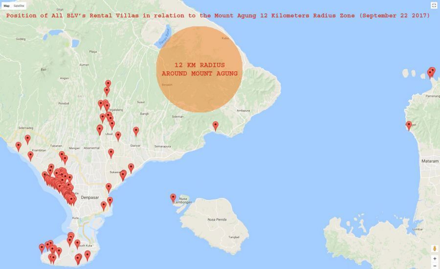
All villas managed or rented by Bali Luxury Villas are located much further away than the current risk radius of 12 km (See Map Below). In regards to any flight cancellations policies due to Volcanic activities, please check with your airline and travel insurance.
BALI September 22 2017 (15:30 GMT): Update
The National Disaster Mitigation Agency said that residents or tourists should stay outside a radius of 12 km from Mount Agung. The airport remains opened.
https://www.bnpb.go.id/home/detail/3465/STATUS-AWAS-UNTUK-GUNUNG-AGUNG
All villas managed or rented by Bali Luxury Villas are located much further away than the current risk radius of 12 km (See Map Below). In regards to any flight cancellations policies due to Volcanic activities, please check with your airline and travel insurance.

BALI September 20 2017 (14:30 GMT)
According to the news Bali’s officials advise that it is currently safe to visit the island even though an alert has been issued. See:
1/ http://www.straitstimes.com/asia/se-asia/bali-officials-say-resort-island-remains-safe-despite-heightened-alert-over-mount-agung
2/ https://www.bnpb.go.id/home/detail/3461/Kepala--BNPB-Tinjau-Pos-Pantau-Gunung-Agung (Bali Regional Disaster Management Agency)
Please note that all villas managed or rented by Bali Luxury Villas are located much further away than the current risk radius of 7.5 km from Mount Agung (See Map Below).
In regards to any flight cancellations policies due to Volcanic activities, please check with your airline and travel insurance.


